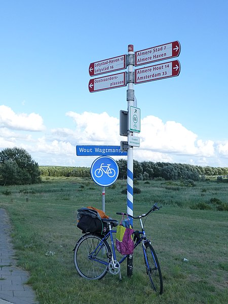
Lelystad, the capital of the Flevoland Province, is sort of an experiment in futuristic architecture, 1970s vintage. There are no street names (other than for several highways crossing the city); rather, buildings are addressed by the name of the neighborhoods they are in. Direction signs are numerous, but often they all have the same work (the name of the neighborhood) in them, with various numbers appended to it. (Referring to building numbers? subsections? God knows...) Asking for directions is rather frustrating; after several "... to the right, and then to the left again..." the informant would conclude, "you see, it's so simple!". I don't know how I could conveniently operate in a place like this, but I figured it probably would not be an obstacle for somebody like my Mom, who has managed to have lived in the same city, on and off, for 40 years, without knowing the names of most streets. (Of course, communicating with my Mom about directions can easily get rather frustrating too).

The downtown Lelystad skyline is dominated by a monument that strangely resembles many a Lenin statue in Russia. However, this is not Lenin, but Lely. Unlike Lenin, Cornelis Lely had his new society created in an area that was previously occupied by the sea (rather than an old society).
There is a major civic center downtown; actually, it seems most of it is dedicated to real estate sales: one of the reasons of draining ("poldering") the Zuider Zee and creating the province of Flevolands on the land that emerged was to relive the population pressure in the rest of the Netherlands... so the local government (or is it a crown corporation of some kind? whoever runs this place...) is still busy selling houses and apartments to prospective migrants.

There was a city library in one of the corners of the center. Although it was closed on Monday, in a wonderful Dutch fashion its free Wi-Fi service was fully operational... and there were even electric outlets in the public areas! Finally I was able to do as much Internet "work" as I needed. I placed an ad on Craigslist.org to sell my bike (as much as I liked it, there was no way I could get it back to North America at a reasonable cost), and got a response right away.

A little mosque on the polder
After having a lunch running a few other errands and having, I finally left the Lelystad area only around 5 pm. Fortunately, days in the Netherlands in August are still along, and the road ahead was pretty nice.

On the Oostvaardersdijk between Lelystad and Almere, looking back (east). The Ijsselmeer (which is at the sea level) is on the left, the Oostvaardersplassen (part of the Flevoland polder system) in on the right... and it is visibly lower!
When I was in the Netherlands the first time, some 7 years ago, I wondered if I can get to a place where you can actually see, from a single point, both the sea (or at least some waterway at the same level) and some dry land that's below the sea level. An iconic Netherlands picture, as I'd imagine it. I did not have a chance to get to a location like that on that occasion... but now I finally had a full day of it! I rode on the Oostvaardersdijk, the dike that forms the northern border of the Flevoland polder system. And it certainly did look like that the polder is below the sea level!
Riding on the Oostvaardersdijk was one of the most pleasant sections of the trip: obviously, the dike is straight, and its top is flat... The road surface is smooth, and there are no crossing roads. As you pass Almere, signs start showing distance to destinations on the "mainland", including Amsterdam.

Now, on to Amsterdam!
Everything good ends eventually. So did the Flevoland. The last 20 km of my route went through cute little towns (with cobblestone roads) and some of Amsterdam's grittier suburbs... but by around 10 pm I finally got to my hotel, on Amsterdam's west side. The person who responded first to my "for sale" ad (when I was still in Lelystad) got there too, just a few minutes later... at 50 euro, the bike was good enough deal even in Amsterdam (this was less than half the price I has bought it for at Amsterdam 3 weeks before, 1000 Danish kroner), so at least I did not have the bicycle parking problem on my hands for my last day in Europe.


