Crossing from Yongding County to Pinghe County
I would not have minded staying in the Nanxi Valley for another day, but it was already time for me to leave the tulou country, get to a train station, and back to Wuhan. There are no railways in the "tulou heartland", but a couple railway lines skirt the tulou counties from the northeast and northwest. So I had a few options. The most interesting, and my original plan, was to continue to the south, via Fujian southernmost counties and to Guangdong's seaside Shantou city; but due to a number of delays early on, I did not have time for this anymore. The next time, perhaps... The next most attractive option was to go north, to Longyan, through which one of the Xiamen-Wuhan trains runs. So if I had thought about it, I could have booked myself a ticket on that train, and had a choice of backtracking to the Xiamen/Zhangzhou area or pushing on to Longyan. But I had not thought of that in advance, and realized now that the ticket I had was for a train that does not run through Longyan. (Instead, it was to leave Fujian through a different route, via Zhangpu and Wuyishan). So I decided to go back to Zhangzhou, through which all trains leaving Xiamen for China's hinterland have to pass.
 S309 climbing out of the Nanxi Valley
Still, there were actually two options. One, backtrack via Shuyang Town and Nanjing County. Two, take S309 south to Luxi Town, and then go east via Pinghe County. I chose the latter option, wondering what kind of road is ahead of me.
Indeed I had to wonder: as of the early 2012, Google Maps shows the new S309 route, going from the north, end in the middle of the Nanxi Valley, although sogou.com and printed maps show it going all the way through to Luxi and beyond. The truth, as I was to found out later this day, was to lie somewhere in the middle.

A shrine in the field, a familiar Fujian sight. (Upper Nanxi Valley)
As I left Shijia Village, the new road (S309) continued - and it was obvious that it was very new, with some construction work not finished yet. Certainly no mile markers, and few signs. Dense human population ended after Shijia, although a few scattered farmhouses and tulous could still be seen for a while here and there on the valley's slopes.
The mountains that separate Yongding County (where Nanxi Valley is) and Pinghe County (where Luxi is the first town) are not particularly high; according to Google Maps Terrain view, the elevation at the pass is somewhere between 800 and 1000 m. (Pretty much the same as on the Kettle Valley Railway between Penticton and Kelowna...) Still, they are pretty steep, and the terrain necessitated quite a bit of engineering tour de force on the part of the designers and builders of the new S309 (the one that Google Maps don't show yet; the Google Maps satellite view photos, being somewhat out of date, show the road still very much under construction). (I don't know how this range is actually called; some maps have Bopingling Range (博平岭) written all across the region, but I think that name properly applies only to a rather more northerly area, closer to Longyan City).
The traffic was very light; at some point, I saw a truck maybe a hundred meters below me (a kilometer or so by the road), and I saw that same truck - and no other vehicles - for the next 15 minutes, as it was gradually catching up with me on the winding road. At some point, there was a sign for a junction with what apparently had been the main road of the Nanxi Valley _before_ the new S309 was built: and that, of course, was just a dirt road with stones of all sides liberally mixed in.

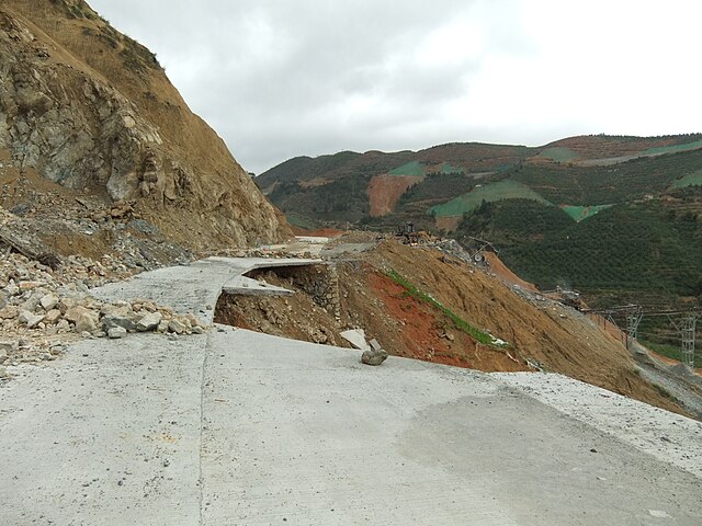
S309: An occasional washout. (The green stripes on the hill slopes on the horizon are the mesh fabric used to cover newly exposed soil above the new roadway, where a retaining wall is going to be constructed later)
In many areas the slopes above the new road were covered with green mesh; presumably, this is where concrete retaining walls will be built soon. One could see construction teams with their trucks and bulldozers at a few places, putting finishing touches on the road itself, or fixing a washout.
When going over the main mountain pass - from Yongding County to Pinghe County - I'd occasionally see grapefruits (or, rather, pomelos) scattered along the road side. Pinghe County, as I was to learn the next day, was famous for its pomelos, but how did they get here, far from the orchards? It would be a strange idea for someone to drive 10 km (and climb at least 500 m) just to throw out some pomelos, and, anyway, most of them did not even look spoiled. I hope it was simply the case of a few boxes or bags of the fruit falling off a truck (or just a motorcycle, as the case may have been) taking them from Pinghe County to some market in the north, rather than that of a fruit-laden truck falling into the precipice, leaving just a few fruit behind! I picked a couple, and they are turned out pretty big.

Hengkeng, one of the first farmsteads on the Pinghe side of the county line
Eventually the road started going downhill, and soon the first villages belonging to Luxi Town, the first town of Pinghe County, appeared. Once in the populated area, the one kind of sign you'd notice was the one painted over all kind of stone markers or just fences: a promise to buy turtles (乌龟) at a good price, with the turtle purchaser's mobile phone number. I guess I should be glad I am not a turtle...

I am glad I am not a turtle!
I decided not to go to Luxi itself (which did not look that attractive from the road), but to continue for another 20 km or so to Xiazhai, the next town, over another minor mountain range. After about 3/4 of the way, I was out for a surprise: a few kilometers before Zhongteng Village (钟腾村) the new road suddenly ended at a construction site - apparently, the next few kilometers were still very much under construction, with gravel being laid and concrete being poured; there was no way through even for a bicycle. So now I knew why the traffic had been so light...
It was dark already, and going back would be silly, so I followed the "detour" such as there was - a dirt road climbing a mountain slope. The recent rain had turned the "road" into something that looked more like a river of mud. It was not of course all that different from any other dirt roads one would find in these mountains, so coming to a fork you'd try to figure the right direction by looking at vehicles' tracks, or waiting for a vehicle to pass - hopefully, in the right direction.
At some point, the dirt road came to a large and well-built rural house, almost a villa, from which music was heard, and I had a momentary doubt: maybe all those (few) cars I had seen had just being going to the villa owner's party, rather than following the detour? But I told myself that going back would be even sillier, and kept one; sure enough, after a while the lights of a truck coming in the opposite direction showed in the dark, and in another 10 min perhaps we met and passed each other; so this was a detour road indeed. It felt like navigating this river of mud took forever, but in reality probably it wasn't more than an hour. Eventually, I was back on the road, with enough clay stuck to my bike to build a tulou.

Xiazhai's tire shop & hotel
Pretty much every Chinese town (zhen) has at least one hotel of some kind, but Xiazhai's main street did not seem to have prominent signs for any kind of accommodation. Despite the late hour, a noodle shop was open, and the people working it were quite positive that a hotel was right there, on the next block, "right where they are fixing cars".
 Morning in Xiazhai. Looking back to the hills I had come from the day before.
Well, there was indeed a tire shop there which I had already passed without paying much attention to; only now did I realize that there ~was~ indeed an "accommodation" sign on this building too! As it turned out, the owners (who apparently owned two building, across the street from each other) operated on a rather unique business model: tire shop downstairs and hotel rooms upstairs! The rate was rather high for a small town like this (80Y), but the room was nice, although with a little quirk: the manager was apparently very reluctant to give guests room keys, even for an additional deposit. (This is something I saw often in rural Hubei in 2008, but never since). Anyway, I got the key (although she came to collect it early the next morning, way before the actual checkout time), and got a good sleep on my last Fujian night.

This is where China's Walmart gets its pomelos (according to the sign)
In the morning, Xiazhai looked pretty nice. It is a local center for a thriving citrus fruit industry (apparently, "Pinghe County honey pomelos" are famous; they even have their own blog, in English), and had a nice farmers market just a block from my hotel, but there was not much to do here. I decided to leave early, and ride to Pinghe County seat (Xiaoxi Town), with a few detours to interesting sites along the road, and then take a bus from Pinghe to Zhangzhou.
 Kids riding home from school

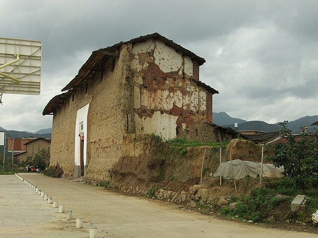
The front (southern) wall of Xishuang Lou: all stages of decomposition
One place I decided to see was Xishuang Lou (西爽楼), which the "exemplary tulous" table Huang Hanmin's book described as a huge rectangular tulou originally built in 1696. It was in Xi'an Village, a couple kilometers north of town along a pleasant rural road running across pomelo orchards. (This road actually continues to Luxi, and, according to the locals, is in fact the main route taken now by the traffic that would have gone on S309 if it had not been closed for construction). As it turned out - and which, alas, is fairly typical - Xishuang Lou is mostly in ruins, with just a few sections still standing.

Xishuang Lou: southern and eastern wall, or what's left of them

A round tulou in Xili village (Xiazhai Town): outside...

... and inside. Most residents have apparently moved to more modern housing nearby.
To be continued...
No comments:
Post a Comment