Showing posts with label tulou. Show all posts

2012-04-26

Hekeng


Hekeng Village, general view. As usual, all images are clickable.

[Previous: Kinmen ferries] - 2012-03-01 - [Next: To the Tulou Great Wall]

Hekeng Village (河坑村), or Hekeng Tulou Cluster, is one of the 10 sites collectively inscribed as the "Fujian Tulou" on the UNESCO World Heritage List. It is indeed a complete village, with a dozen or so full-size tulou, plus some smaller adobe buildings. Now, there are probably a lot more than ten villages in Fujian's "Tulou Country" (primarily, Nanjing, Yongding, and Pinghe Counties) where one can find a dozen tulous, but Hekeng is remarkable for its absence of out-of-style "modern" (concrete) buildings - neither in the village itself, nor anywhere in site. So the entire village got inscribed as a heritage site, unlike, for example, Gaobei Village, where the "official" heritage site only includes the famous Chengqi Lou and a few neighbors.


The village temple. I suppose a feng shui expert was retained to site it correctly, with the hill behind and a water feature in front.
Same temple, with ducklings enjoying the water feature. (Plenty of ducks in the area, in general)
The ducklings

Unlike Gaobei or Hongkeng, surrounded by parking lots and full of vendors and other accoutrements of tourist trade, Hekeng apparently still is not on the tourist circuit. There are a few information plaques here and there, but that's about it. Probably, tourist buses stop here occasionally (this, after all, is just off the newly redone X562 - the main road from Xiamen and Shuyang to Gaobei and Yongding), but there were none during my visit. The place looks like a perfectly normal living and working village, and most tulous are still lived in.


Hekeng's Yuchang Lou. (The name is used elsewhere as well). With some seating in front of the main entry, motorcycle parking space, and space for laundry, the ancient tulou has many of the important features one expects of a 1970s Soviet apartment building.

Look-into-a-tulou (Yuchang Lou)

Inside Yongsheng Lou - one tulou that seems to be mostly deserted. Whenever you enter a tulou, there is this immediate feeling of a contrast between a hot sunny day outside, and a cooler, shady environment inside, as evidenced by the mossy floor.


Qujiang

Bus stop at Qujiang, with half a dozen buses a day to Xiamen.

As one goes west, Qujiang is the next village after Hekeng. It is less than a quarter mile away, but you can't see it from Hekeng (or vice versa), because they are separated by the shoulder of a small mountain, with a short tunnel taking the new road through it. (In the past, it must have been a longer drive or walk between the two villages). Qujiang is rather bigger than Hekeng; it may have as many tulous as Hekeng does, but they are now interspersed with modern buildings, such as the local school complex (which probably serves several nearby villages, including Hekeng).

Link: more pictures of Hekeng and Qujiang.

[Previous: Kinmen ferries] - 2012-03-01 - [Next: To the Tulou Great Wall]

2012-04-12

The home of the pomelo


Crossing from Yongding County to Pinghe County
Previous: to the Tulou Great Wall -- (2012-03-04) --

I would not have minded staying in the Nanxi Valley for another day, but it was already time for me to leave the tulou country, get to a train station, and back to Wuhan. There are no railways in the "tulou heartland", but a couple railway lines skirt the tulou counties from the northeast and northwest. So I had a few options. The most interesting, and my original plan, was to continue to the south, via Fujian southernmost counties and to Guangdong's seaside Shantou city; but due to a number of delays early on, I did not have time for this anymore. The next time, perhaps... The next most attractive option was to go north, to Longyan, through which one of the Xiamen-Wuhan trains runs. So if I had thought about it, I could have booked myself a ticket on that train, and had a choice of backtracking to the Xiamen/Zhangzhou area or pushing on to Longyan. But I had not thought of that in advance, and realized now that the ticket I had was for a train that does not run through Longyan. (Instead, it was to leave Fujian through a different route, via Zhangpu and Wuyishan). So I decided to go back to Zhangzhou, through which all trains leaving Xiamen for China's hinterland have to pass.

S309 climbing out of the Nanxi Valley

Still, there were actually two options. One, backtrack via Shuyang Town and Nanjing County. Two, take S309 south to Luxi Town, and then go east via Pinghe County. I chose the latter option, wondering what kind of road is ahead of me.

Indeed I had to wonder: as of the early 2012, Google Maps shows the new S309 route, going from the north, end in the middle of the Nanxi Valley, although sogou.com and printed maps show it going all the way through to Luxi and beyond. The truth, as I was to found out later this day, was to lie somewhere in the middle.


A shrine in the field, a familiar Fujian sight. (Upper Nanxi Valley)

As I left Shijia Village, the new road (S309) continued - and it was obvious that it was very new, with some construction work not finished yet. Certainly no mile markers, and few signs. Dense human population ended after Shijia, although a few scattered farmhouses and tulous could still be seen for a while here and there on the valley's slopes.

The mountains that separate Yongding County (where Nanxi Valley is) and Pinghe County (where Luxi is the first town) are not particularly high; according to Google Maps Terrain view, the elevation at the pass is somewhere between 800 and 1000 m. (Pretty much the same as on the Kettle Valley Railway between Penticton and Kelowna...) Still, they are pretty steep, and the terrain necessitated quite a bit of engineering tour de force on the part of the designers and builders of the new S309 (the one that Google Maps don't show yet; the Google Maps satellite view photos, being somewhat out of date, show the road still very much under construction). (I don't know how this range is actually called; some maps have Bopingling Range (博平岭) written all across the region, but I think that name properly applies only to a rather more northerly area, closer to Longyan City).

The traffic was very light; at some point, I saw a truck maybe a hundred meters below me (a kilometer or so by the road), and I saw that same truck - and no other vehicles - for the next 15 minutes, as it was gradually catching up with me on the winding road. At some point, there was a sign for a junction with what apparently had been the main road of the Nanxi Valley _before_ the new S309 was built: and that, of course, was just a dirt road with stones of all sides liberally mixed in.


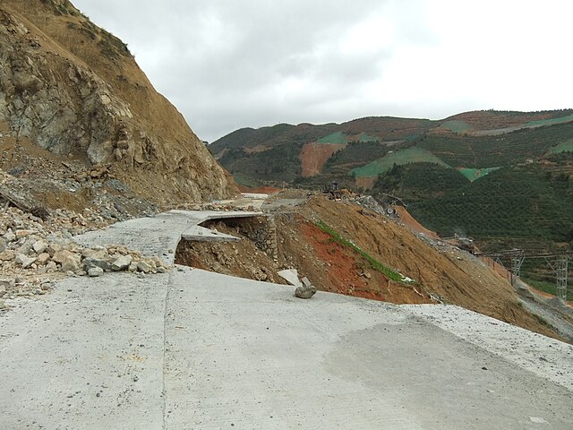
S309: An occasional washout. (The green stripes on the hill slopes on the horizon are the mesh fabric used to cover newly exposed soil above the new roadway, where a retaining wall is going to be constructed later)

In many areas the slopes above the new road were covered with green mesh; presumably, this is where concrete retaining walls will be built soon. One could see construction teams with their trucks and bulldozers at a few places, putting finishing touches on the road itself, or fixing a washout.

When going over the main mountain pass - from Yongding County to Pinghe County - I'd occasionally see grapefruits (or, rather, pomelos) scattered along the road side. Pinghe County, as I was to learn the next day, was famous for its pomelos, but how did they get here, far from the orchards? It would be a strange idea for someone to drive 10 km (and climb at least 500 m) just to throw out some pomelos, and, anyway, most of them did not even look spoiled. I hope it was simply the case of a few boxes or bags of the fruit falling off a truck (or just a motorcycle, as the case may have been) taking them from Pinghe County to some market in the north, rather than that of a fruit-laden truck falling into the precipice, leaving just a few fruit behind! I picked a couple, and they are turned out pretty big.


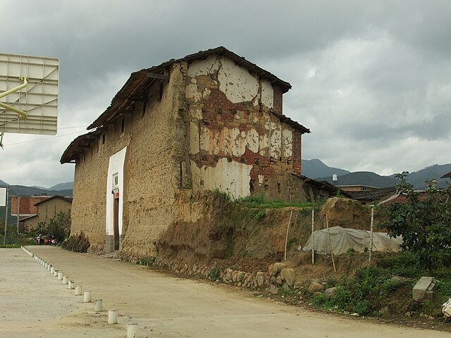
Hengkeng, one of the first farmsteads on the Pinghe side of the county line

Eventually the road started going downhill, and soon the first villages belonging to Luxi Town, the first town of Pinghe County, appeared. Once in the populated area, the one kind of sign you'd notice was the one painted over all kind of stone markers or just fences: a promise to buy turtles (乌龟) at a good price, with the turtle purchaser's mobile phone number. I guess I should be glad I am not a turtle...


I am glad I am not a turtle!

I decided not to go to Luxi itself (which did not look that attractive from the road), but to continue for another 20 km or so to Xiazhai, the next town, over another minor mountain range. After about 3/4 of the way, I was out for a surprise: a few kilometers before Zhongteng Village (钟腾村) the new road suddenly ended at a construction site - apparently, the next few kilometers were still very much under construction, with gravel being laid and concrete being poured; there was no way through even for a bicycle. So now I knew why the traffic had been so light...

It was dark already, and going back would be silly, so I followed the "detour" such as there was - a dirt road climbing a mountain slope. The recent rain had turned the "road" into something that looked more like a river of mud. It was not of course all that different from any other dirt roads one would find in these mountains, so coming to a fork you'd try to figure the right direction by looking at vehicles' tracks, or waiting for a vehicle to pass - hopefully, in the right direction.

At some point, the dirt road came to a large and well-built rural house, almost a villa, from which music was heard, and I had a momentary doubt: maybe all those (few) cars I had seen had just being going to the villa owner's party, rather than following the detour? But I told myself that going back would be even sillier, and kept one; sure enough, after a while the lights of a truck coming in the opposite direction showed in the dark, and in another 10 min perhaps we met and passed each other; so this was a detour road indeed. It felt like navigating this river of mud took forever, but in reality probably it wasn't more than an hour. Eventually, I was back on the road, with enough clay stuck to my bike to build a tulou.


Xiazhai's tire shop & hotel

Pretty much every Chinese town (zhen) has at least one hotel of some kind, but Xiazhai's main street did not seem to have prominent signs for any kind of accommodation. Despite the late hour, a noodle shop was open, and the people working it were quite positive that a hotel was right there, on the next block, "right where they are fixing cars".

Morning in Xiazhai. Looking back to the hills I had come from the day before.

Well, there was indeed a tire shop there which I had already passed without paying much attention to; only now did I realize that there ~was~ indeed an "accommodation" sign on this building too! As it turned out, the owners (who apparently owned two building, across the street from each other) operated on a rather unique business model: tire shop downstairs and hotel rooms upstairs! The rate was rather high for a small town like this (80Y), but the room was nice, although with a little quirk: the manager was apparently very reluctant to give guests room keys, even for an additional deposit. (This is something I saw often in rural Hubei in 2008, but never since). Anyway, I got the key (although she came to collect it early the next morning, way before the actual checkout time), and got a good sleep on my last Fujian night.


This is where China's Walmart gets its pomelos (according to the sign)

In the morning, Xiazhai looked pretty nice. It is a local center for a thriving citrus fruit industry (apparently, "Pinghe County honey pomelos" are famous; they even have their own blog, in English), and had a nice farmers market just a block from my hotel, but there was not much to do here. I decided to leave early, and ride to Pinghe County seat (Xiaoxi Town), with a few detours to interesting sites along the road, and then take a bus from Pinghe to Zhangzhou.

Kids riding home from school

The front (southern) wall of Xishuang Lou: all stages of decomposition

One place I decided to see was Xishuang Lou (西爽楼), which the "exemplary tulous" table Huang Hanmin's book described as a huge rectangular tulou originally built in 1696. It was in Xi'an Village, a couple kilometers north of town along a pleasant rural road running across pomelo orchards. (This road actually continues to Luxi, and, according to the locals, is in fact the main route taken now by the traffic that would have gone on S309 if it had not been closed for construction). As it turned out - and which, alas, is fairly typical - Xishuang Lou is mostly in ruins, with just a few sections still standing.


Xishuang Lou: southern and eastern wall, or what's left of them
Unlike Rome's Coliseum, which has withstood 2000 years of neglect, a tulou needs to be lived in and cared for in order to survive. If the wooden roof is damaged, the rainwater soon will erode the walls; wooden framework may start falling apart, taking more of the rood with it, and sooner than you can say "deferred maintenance", you'll end up with a huge pile of clay. I had seen all the stages of this process in the numerous partially damaged, mostly dilapidated, or fully fallen apart tulous along my route, but at the gigantic Xishuang Lou, it seemed, you could observe all these stages at the same site. The front gate area was nicely repaired, though.

A round tulou in Xili village (Xiazhai Town): outside...

... and inside. Most residents have apparently moved to more modern housing nearby.

To be continued...

2012-03-29

To the Tulou Great Wall

Guibi Lou - just an average tulou from Xinnan Village. Not "World Heritage", like Yanxiang Lou
-- (2012-03-03) -- Next: The home of the pomelo

After 2 nights in Gaotou Township's Chengqi Lou, I went farther west. In Huang Hanmin's "Fujian Tulou" I had seen a photo of the area that the local tourism promoters call "The Great Wall of Tulous": a chain of villages that mostly consist of tulou and similar adobe buildings, and present quite an imposing picture if viewed from a suitable view point.

Some weeks before, at an early planning stage, I saw that area with Google Maps satellite view almost as soon as I zoomed on the tulou region and started browsing; later, when I actually wanted to find it its exact location on the satellite photos, it took a bit of an effort, but eventually I did find an almost exact match of what the photo showed. The village are located in the valley of the Nanxi ("South Creek") south of Hukeng Town, roughly from Shijia Village in the south to Xin Nancun ("New South Village"; on Google Maps) in the north, and are almost as impressive on the satellite photos as on the photo in the book. So the area is sometimes referred to as the "Nanxi Great Wall of Tulou".

Getting to the "Great Wall" on the ground was easy enough: the new county road continues west from Gaotou to Hukeng, and from there, you take Provincial Highway 309 (S309) to the south. The highway runs along the western side of the Nanxi Valley, while the villages, connected by an old (very poor) road, sit in the valley to the east of the road. This very new highway sometimes made an almost surreal impression: it is a perfect new road with very few vehicles on it, and with only few - and quite poor - connections to the villages where the people are. It is as if the road has been built to serve the tourists and the transit traffic, neither of which are here yet (and the next day, I was to find out why), rather than the locals. However, I saw at least one connector bridge under construction, so hopefully it all will come with time.

Tulou ruins. Xipian Village.
Tulou ruins. Xinnan Village.
Tulou ruins. Yangduo Village.

Although my maps very quite unambiguous as to where the tulou villages were, apparently that wasn't as clear to everyone. At some point, a car with a family of tourists came from the south, the driver asking me - and then a more knowledgeable local farmer - "" (So where are the tulou?). That was somewhat discouraging, but I kept going, and after a few more kilometers, the first major tulou village, Xin Nancun, appeared. My maps mentioned that one of the World-Heritage-listed tulou, the Yanxiang Lou, was in the village, but looking from the highway I would have no idea which one it was: the village, stretched along both sides of the Nanxi Creek, had several impressive large round and square tulous, each of which certainly would deserve heritage listing. After a bit of riding and picture taking, I got to a square tulou posted as some kind of Hakka Lifestyles Exhibition; it had apparently been restored and maintained in a decent condition, but there wasn't actually much of an "exhibit" to be seen, beyond, of course, the building itself. The Yanxiang Lou turned out to be nearby as well. While posted with tourist information, it did not have any tickets vendors or tourist crowds, and certainly was pleasant to see.

In Xinnan Village (Xinnancun)
Inside Yanxiang Lou

As I went farther south along the tulou villages, I enjoyed the views and took pictures, but I wanted to find a high viewpoint similar to the one used by the photographer who took the photo in Huang Hanmin's book. I climbed a bit along one westbound trail, but it did not seem to provide any useful viewing opportunities. However, a bit later, near Nanjiang Village, a purpose-built winding road climbed a mountain on the western side of the valley, with a sign inviting tourists to visit an observation tower. So I did. You can drive or ride - well, push the bike, most likely - up the road, or you can walk up a shorter but steeper trail through the forest; I chose the latter. The view indeed was worth the climb. However, the tower was not located as far south as the view point of the photographers in the book; looking north, you'd only seen the northern half of what they got.

The deceased liked psychodelic colors...
Nanjiang Village, a section of the "Tulou Great Wall", seen from the observation tower
Nanjiang (center)Nanjiang (south)Shijia

Down on the highway, I kept south, passing another villages (Shijia), where slogans painted above the tulou entrances asked for "10,000 years for Chairman Mao", or at least for Mao Zedong's Thought. I felt I just have to stay for a night there, and try another photo-op chance tomorrow.

Shijia Village, Dongxing Lou

I could start my description of the place with "The time has stopped on the cobblestone streets of Shijia", except that there were really no streets there: a cobblestone square between several tulous, then a narrow, pedestrian- or moped-only alley to the next opening, and so one. As I said, the "modern" traffic, such as there was goes on the new highway S309 west of the village, and the old road (which is basically dirt road with some stones mixed in for a good measure) skirts the village from the east.

Shijia Village. The Cultural Revolution continues!

No wonder few tourists ever make it to Shijia. I did not expect to find any travel-related infrastructure there, but there was at least a grocery store there, and when I inquired, on the off chance, whether there is any kind of accommodation (''zhusu'') available in the village, the owner merely responded: "How many people?". As it turned out, he had some nearly empty rooms on the second floor of his, and did not mind renting them out to travelers - and feeding them, too - at a reasonable price. (To be honest, I don't know if he does it regularly, or I was the first person to ask, but if the latter, he certainly was able to think on his feet. I hope that with the new road, more people will come to Shijia and put some money into the pockets of the locals who are willing to rent rooms.)

In a sense, I wish I had a chance to stay in a tulou again, as I had in Gaoutou, but, really, I did not mind being in a fairly comfortable modern house again. And there was a tulou just across an alley...

Shijia Village, Yuqing Lou. I stayed across a street... "an alley" from it

(2012-03-04) The one-room grocery shop was, apparently, also a social club of sort for the owner's friends, who'd sip tea or play mah-jong there. I don't speak much Chinese, and the for the region's Hakka people Mandarin also must be a second language, but with a pen and paper we were able to communicate to some extent.
"Coming from Canada, you must know about Dr. X!" (I missed the name).
"Doctor? I am afraid I don't think I know any doctors... What's his name anyway... 白 Bai- 求 qiu- 思 si? No idea!"
"It's not 思 si, it's 恩 en".
白求恩 "Bai-qiu-en... Ah, Dr. Bethune, of course, the hero of the anti-fascist wars in Spain and in China!"
(Dr. Bethune, a Montreal surgeon, died in 1940 while treating Red Army's wounded soldiers during the war against Japanese invaders, and became well known after Mao Zedong himself wrote about him.)

"So you are out there to look at tulous?" A reasonable guess, indeed, as in Shijia you'd see a tulou or a few wherever you look. One of the hospitable grocer's mah-jong partners turned out to be a local history enthusiast. A grandson of a local master craftsman (Jiang Lin'en, 江林恩, a.k.a. Ah Man Shi 阿满师), he proudly showed his collection on books and magazine articles of the tulou country's lore, some of which he (Jiang Shengzhan 江生赞) wrote himself. This was certainly a lot more writing on this topic than I'll ever read in my life... Mr. Jiang kindly showed me around "his" tulou: Nan'an Lou, a rather unusual building, in that it's neither round nor rectangular, but rather D-shaped.

Shijia: not the best view

I spent a few hours in mid-day hiking in the hills southwest of Shijia, but could never find a position from which one could get a view exactly like the "Great Wall" photographers did. Either they had a helicopter and a day of an exceptionally good visibility, or they were able to climb a cell phone tower, or the fruit trees which block some of the best views now had not grown at that time yet. Most likely, of course, they simply knew the terrain a lot better than I did.

By mid-afternoon it was time to leave Shijia, if I was to get anywhere else before too late at night. There were several options I could pursue - go back to Hukeng, and then north or northwest toward Yongding or Longyan; backtrack from Hukeng to the east, toward Shuyang and Nanjing County to Zhangzhou; or choose the southern route to Zhangzhou, via Pinghe County. I chose the last option...

Next: The home of the pomelo